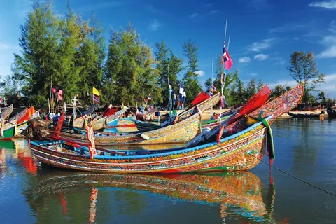
This page covers the two sides outside Pattani town. The coast in Yaring district has Laem Tachi, Talo Kapo beach and the Bang Pu and Bunadara communities, and the Khok Pho side has Wat Chang Hai, known for Luang Pu Thuat. The two sides are far apart and far from the old town, so you have to choose which to do and how.
Yaring is one of the Pattani districts on the list of areas declared under the Internal Security Act, which the Cabinet extended on 29 Sep 2026. Below are the facts and the workable options: go by day, go with a group or a community, stay in town and check your insurance. For the summary, see Is Pattani safe. As of 14 Nov 2026.
We earn a commission if you book through our links. The price you pay does not change. How we choose
Summary before you go: the sights, distances, times and how to get there
The Pattani coast and Wat Chang Hai are two different sides. The coast in Yaring has Laem Tachi, Talo Kapo beach and the fishing communities of Bang Pu and Bunadara, and suits people who like the sea, fishing boats and mangroves. Wat Chang Hai in Khok Pho suits people who come to pay respect to Luang Pu Thuat and see the stupa. All are free, and no public bus that a visitor can use reaches them, so you need a car or a hired ride.
| Place | Where | Approx. distance from town | Hours | Time needed |
|---|---|---|---|---|
| Laem Tachi | Yaring, the curved sand spit that shuts off Pattani Bay | About 43 km by road, or about 30 min by boat from Bang Pu | About 08:00 to 18:00 | Half a day |
| Talo Kapo beach | Yaring, rural road Pn.4031 | About 40 km (some routes are shorter, check the map) | No fixed hours | 1 to 2 hours |
| Bang Pu and Bunadara | Yaring, bayside tourism communities | Check the map, on the same stretch as Talo Kapo | Ask the community | Mangrove boat trip about 2 h |
| Wat Chang Hai (Wat Ratburana) | Khok Pho, next to Wat Chang Hai railway station | About 30 km | About 08:00 to 17:00 | 1 to 1.5 hours |
All figures are estimates as of 14 Nov 2026, so check the hours and the route before you go. The places lie in different directions, so if time is short choose one side. From Hat Yai, some trains put you down at Wat Chang Hai station right beside the temple, while the coast needs a car. The cards below are what you can book.
 Klook
Hat Yai Car Rental
From US$23.69 (Starting price per day, compact car, as of 13 Nov 2026)
Price as of 13 Nov 2026The coast and Wat Chang Hai have no practical public bus. Hiring a car at Hat Yai airport lets you go on your own timing. A compact car starts from about US$23 a day as of 13 Nov 2026. Ask about the deposit and driver age on the booking page, drive by day and be back before dark. Foreign visitors should carry an international driving permit. Prices change by date and car.
Car hire in Hat Yai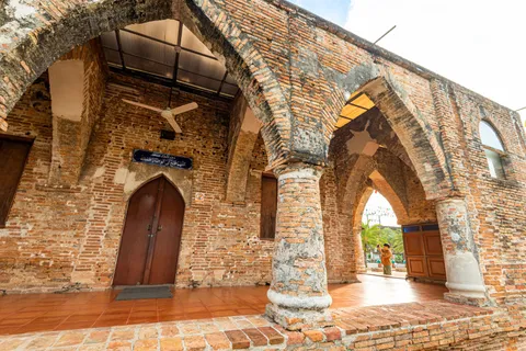 12Go
Hat Yai to Pattani (train, van, taxi)
From US$2 (Sample date 19 Nov 2026, as of 14 Nov 2026. Trains from about US$2, vans from about US$16. Prices change by date and trip)
Price as of 14 Nov 2026To reach Wat Chang Hai by train from Hat Yai, fares start from about US$2 as of 14 Nov 2026, sample date 19 Nov. It takes about 1 h 10 min to 1 h 25 min and stops at Pattani station or Wat Chang Hai station, so check which one your trip uses. Bus and van trips take about 2 h, with vans from about US$16. Prices change by date and trip.
See Hat Yai to PattaniYaring is on the security-area list: the facts and workable options
There are two facts. First, on 29 Sep 2026 the Cabinet extended the area declaration under the Internal Security Act (2008) for 19 districts in 4 provinces by one more year, from 1 Oct 2026 to 30 Sep 2027. The Pattani districts on the list are Yaring, Panare, Mayo, Mai Kaen, Thung Yang Daeng, Kapho and Mae Lan. Yaring, which holds Laem Tachi, Talo Kapo beach, Bang Pu and Bunadara, is on that list. Mueang Pattani, which holds Krue Se Mosque, the Lim Ko Niao shrine and the Central Mosque, and Khok Pho, which holds Wat Chang Hai, are not on it.
Second, foreign governments publish advice for the far south. As of 15 Nov 2026 the UK Foreign Office (FCDO) advises against all but essential travel to Pattani, Yala and Narathiwat provinces, and Australia's Smartraveller says to reconsider your need to travel to those three provinces. Travel insurance may be invalidated if you travel against advice. Read your own government's page and the summary table on Is Pattani safe.
Workable options
| Option | How | Best for |
|---|---|---|
| Daytime only | Leave town in the morning, be back before dark, avoid driving outside town after dark | People staying in town who want to see the coast |
| With a group or community | Contact the Bang Pu or Bunadara tourism community first and ask about boats, times and prices | People who want a local guide |
| Skip the coast | See the old town and Wat Chang Hai, which are not on the list | People uneasy about Yaring |
| Check insurance and advice | Read the policy wording on area and activities, and check your own government's latest advice | Everyone, before booking rooms and tickets |
| Carry documents | Carry your passport or ID, because checkpoints are common on the roads | Everyone |
The area declaration under the Internal Security Act is not a Thai government tourist warning, and it is not a verdict on any single place. The Thai government is reducing its use of the Emergency Decree in these areas, and that may change, so check the latest news and advice before you set out.
How to combine them: half-day and one-day plans and distances
The problem on this route is that the two sides lie in different directions. Wat Chang Hai is to the south-west of town, about 30 km, and the Yaring coast is to the east, about 40 to 43 km. Do not plan both sides without a car and spare time. The table below helps you choose, and you should check real driving times on the map first.
| Plan | Order | Time | Best for |
|---|---|---|---|
| Half day, Wat Chang Hai | Leave town or Hat Yai in the morning, the temple about 08:30 to 10:00, then lunch and return | Half a day | People who come to pay respect, like temples or arrive by train |
| Half day, coast by road | Town, Highway 42, Pn.2062, Talo Kapo, lunch, Laem Tachi if time allows, back before dark | Half to one day | People with a car who like the sea and fishing boats |
| Half day, coast by water | Go to the Bang Pu or Bunadara pier for a mangrove trip of about 2 h, or take the boat to Laem Tachi, about 30 min | Half a day | People who like mangroves and want a local guide |
| One day, both sides | Wat Chang Hai in the morning, lunch in town, a short coast visit in the afternoon, back before dark | A full day, with a car | People with a car and only one day in Pattani |
One day for both sides is possible but tight, and you should not add the old town to it. With two days, put the old town on one and the coast and Wat Chang Hai on the other. See the full plans on the 1-day and 2-day plans and the old-town details on Old town, Krue Se and the Lim Ko Niao shrine.
Distances between the points
| From | To | Approx. distance | Note |
|---|---|---|---|
| Pattani town | Laem Tachi | About 43 km | Highway 42 for about 12 km, then Pn.2062. Check the map |
| Pattani town | Talo Kapo beach | About 40 km | Same route, past the Bunadara pier |
| Talo Kapo beach | Laem Tachi | Check the map | The road runs on past the beach to the spit |
| Pattani town | Wat Chang Hai | About 30 km | Highway 42 past the Na Ket junction, then Highway 409 through Na Pradu, left at the temple gate for about 800 m more |
| Bang Pu or Bunadara pier | Laem Tachi (by water) | About 30 min by boat | Ask for the price and times at the pier |
Laem Tachi (Laem Pho): by boat or by road, hours and what you will find
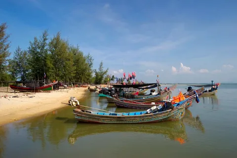
Laem Tachi, also called Laem Pho, is a sand spit with a tip that curves like the letter C. It shelters Pattani Bay, the inner sea, from the Gulf of Thailand, the outer sea. On the inner side facing the mainland there are fishing villages such as Ban Dato, Ban Talo Samilae and Ban Budi, where people fish and farm sea bass, cockles and mussels. The outer side facing the open sea has several private stays. From the tip you can see both sunrise and sunset from one spot.
| Entry | Free |
|---|---|
| Hours | About 08:00 to 18:00. Check before you go |
| By road | Highway 42 for about 12 km, then left onto rural road Pn.2062 (the lane by Yaring post office), over the Yamu canal bridge, past the market, left toward Talo Kapo and on to the end, about 43 km in all |
| By water | A boat from the Pattani river mouth or the Bang Pu and Bunadara piers, about 30 min. Ask for the price at the pier |
| Phone | 0 7335 3441 (check before you call) |
| Time needed | About 1 to 2 hours at the spit, plus travel |
Going by boat shows you the bay and the mangroves on the way. If you prefer to drive, take the road, which is simpler to plan, and leave time to get back to town before dark. Boat prices and times are set locally, so ask at the pier or the community before you go.
Sunset from the tip is a draw, but plan to visit by day and return to town before dark. If sunset matters to you, an overnight stay on the coast is the only way, so read the stays section first and ask your hotel about local conditions.
Bang Pu and Bunadara: mangrove boat trips and the mangrove tunnel
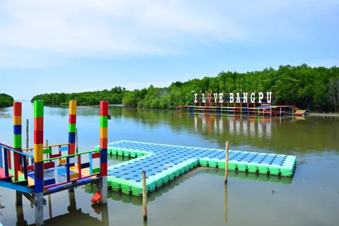
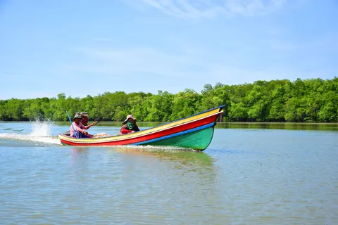
The Bang Pu and Bunadara tourism communities are in Yaring district on Pattani Bay. They are the piers for boats to Laem Tachi and for mangrove trips. At Bang Pu most of the area is mangrove at the mouth of the bay, with the Ko Lae, Kue Ngo and Bang Pu canals. The main activity is a mangrove boat trip of about 2 hours. In places the mangrove branches from both banks arch together into a tunnel about 700 m long, and water birds can be seen along the way. Trips are offered through the year, though wind and rain can stop boats. Contact the community on 08 1805 8761 or 08 6491 2556.
At Bunadara in Talo Kapo subdistrict, the traditional fishing community runs trips in a local boat with a local guide along the connected canals of Pattani Bay, past a spot where fish gather, a bird-watching point and a bamboo deck on the mangroves for resting and views. There is a sidecar tricycle tour of the community, a look at dried-fish making and local seafood to taste. In the morning the community pier has a small market selling fresh seafood from the fishing boats. Contact the community on 08 9975 6057.
| Price | Ask the community first, because prices are set locally |
|---|---|
| Times | Ask the community about boat times. The Bunadara morning market is a morning visit |
| Time needed | Mangrove boat trip about 2 hours |
| Language | Mostly Thai. Prepare a message or ask your hotel to call for you |
| Rainy season | Wind and rain can stop the boats. Ask before you go |
In Mueang Pattani there is also Ban Bana, with a wooden bridge and mangrove boat trips, closer to town. See the details on the old-town page. If you are uneasy about Yaring, Bana offers mangroves too and is in Mueang district.
Talo Kapo beach: the long beach, kolek boats, pines, eateries and what to know
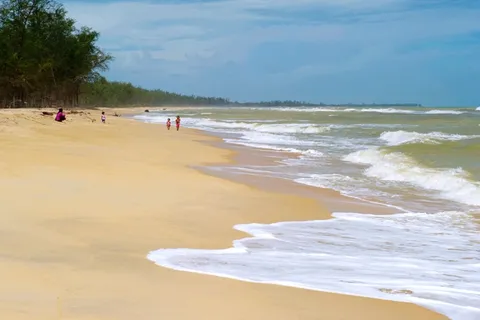
Talo Kapo beach lies south of Laem Tachi. It is a long beach with sea pines and coconut palms running along the sand and the road, local kolek fishing boats lined up on the shore, and stays and eateries spread along it. It suits walking, cycling and quiet time in nature. It is on rural road Pn.4031. The local contact is 0 7352 2411, so check before you call. Entry is free.

| Entry | Free |
|---|---|
| Where | Rural road Pn.4031, Yaring district |
| Distance | About 40 km from town, and some routes are shorter. Check the map |
| The turn | Past the Bunadara community pier for about 500 m, then the turn into the beach is on the right |
| Do here | Walk, cycle, look at the kolek boats, sit at a beachside eatery |
| Time needed | About 1 to 2 hours, or overnight |
If you plan to swim, assume there are no lifeguards on the beach unless you see a sign or ask locals. Go in with care, keep children close and dress modestly, because the beach is in a Muslim community. Revealing swimwear is not suitable. Casual clothes, or swimwear that covers arms and legs, suit better. Do not drink alcohol on the beach.
What to eat at Talo Kapo
Eateries are spread along the beach, and the Bunadara pier has a small market selling fresh seafood in the morning. The food is seafood and local dishes. Prices vary, so ask at the shop before you order and carry some cash, because small shops may not take transfers. Some shops close early, so plan a lunch and then head back.
If you have no car, ask your hotel to arrange a round trip to Talo Kapo in one day and agree the price before you set off. Arrange the ride through your hotel rather than an unplanned charter.
Wat Chang Hai (Wat Ratburana) in Khok Pho and Luang Pu Thuat: hours, access and dress
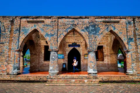
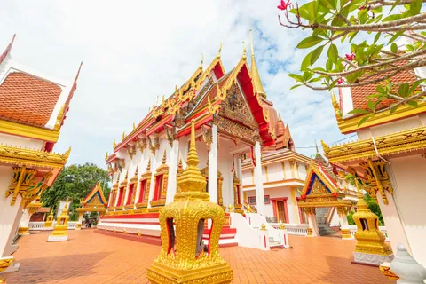
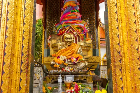
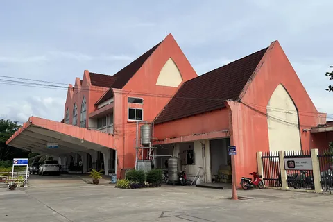
Wat Ratburana, or Wat Chang Hai, stands beside Wat Chang Hai railway station at Ban Pa Rai in Khok Pho. It is an old temple of more than 300 years. What draws people is the life-size statue of Luang Pu Thuat in the vihara and the stupa, about 59 m high, with five spires. The big central spire carries a seven-tier umbrella made of 100 baht-weight of gold set with rubies. Inside the stupa is a hall holding relics, with a cloister around it.

| Entry | Free. Merit-making is optional |
|---|---|
| Hours | About 08:00 to 17:00 daily. Check before you go |
| Where | Beside Wat Chang Hai railway station, Ban Pa Rai, Khok Pho |
| Distance | About 30 km from Pattani town |
| Time needed | About 1 to 1.5 hours |
| Dress | Modest, shoulders and knees covered, shoes off before the vihara |
Luang Pu Thuat is a revered monk and a former abbot of Wat Chang Hai. The best-known story is that he turned seawater fresh so a ship's crew could drink. He later died in Malaysia, and his remains were brought back to Wat Chang Hai. The temple holds a bathing ceremony for his relics on the 1st waning day of the 5th lunar month, about April, so check the real date for the year.
How to reach Wat Chang Hai
| Way | Detail | Note |
|---|---|---|
| Train | Get off at Wat Chang Hai station, which adjoins the temple, or at Pattani station and ride on to the temple. Check which station your trip stops at. The timetable is on the getting-there page | Trains are often late, so check times. Carry your passport or ID |
| Car from town | Highway 42 past the Na Ket junction, Highway 409 through Na Pradu, left at the Wat Chang Hai gate and about 800 m more, about 30 km in all | Suits a half day |
| From Hat Yai | Train about 1 h 10 min to 1 h 25 min, or hire a car and drive. See the booking cards in the summary | A day trip works if you check the return train times |
If you come by train, plan your time at the temple around the return train. Not every train stops at both stations, so check which one your trip uses. The timetable for Pattani station is on Getting to Pattani. If unsure, ask the station staff or call 1690.
What to bring, the rainy season and the best time for the coast and the temple
The coast and the temple are outside town, where shops and services are thinner than in the centre. Preparing ahead makes the day smooth. The list below is what you actually use on this route.
| Item | Why |
|---|---|
| Passport or ID | There are checkpoints on the roads, and you need it on the train |
| Small cash | Small shops, piers and communities may not take transfers |
| Water, hat, sunscreen | The beach and the temple yard are hot with little shade |
| Modest clothes, a shawl | Temples and Muslim communities need shoulders and knees covered |
| Easy slip-off shoes | Taken off before the vihara |
| Umbrella and rain jacket | Rain is frequent late in the year |
| Insect repellent | The mangroves and waterside have mosquitoes |
| Offline map and power bank | Signal may be weak on country roads |
The rainy season and the best time
Pattani is dry about January to April and wettest about October to December, so check before you go. In the wet months wind and rain can stop the boats and make the beach unpleasant. Wat Chang Hai still works because it has roofed areas. In the dry months the sun is strong, so go to the beach in the morning or late afternoon. Weekdays are quieter than weekends and festival times.
| Period | Coast | Wat Chang Hai |
|---|---|---|
| Jan to Apr (dry) | Easiest. Strong sun, go in the morning or late afternoon | Easy, hot at midday |
| Late year (wettest) | Boats may not run, ask before you go | Works, with some roofed areas |
| Lim Ko Niao festival (late Feb to Mar) | Not directly affected, but town rooms may be full | Not affected |
Stays at Talo Kapo and the Yaring coast: when to sleep there and when to stay in town
There are few seafront stays in Pattani. Two can be booked, at Talo Kapo and on the Yaring side, and none near Laem Tachi or Khok Pho are available to book. If you decide to sleep on the coast, arrive in daylight, ask the hotel about local conditions and the route there, and before you book check that your travel insurance covers the area and your own government's latest advice. Yaring is on the Internal Security Act list, as stated above.
| Hotel | Where | Class | Best for |
|---|---|---|---|
| Relax De Tuwah Beach Resort | Talo Kapo, Yaring, beach side | Mid-range | People who want to sleep near the beach and the kolek boats |
| 4U Resort & Camp | Yaring district, coast side. Check the map before you book | Budget (camp), a low price level as of 14 Nov 2026 | People who want a budget stay near the sea |
Relax De Tuwah Beach Resort
Talo Kapo, Yaring district (beach side; Agoda lists it under Mueang Pattani)
A mid-range stay on the beach side of Talo Kapo in Yaring district, for people who mean to sleep near the beach and the kolek boats. No stay at Laem Tachi is available to book at the moment. The price changes by date, so check the map, the price and the cancellation terms on the booking page.
See prices and availability on the booking page
4U Resort & Camp
Yaring district (postcode 94150, coast side, check the map)
A budget camp-style stay on the coast side of Yaring district. A low price level as of 14 Nov 2026 that changes by date. How far it is from the beach is not clear, so check the map on the booking page before you choose.
See prices and availability on the booking page
If you do not want to sleep in Yaring, a hotel in town works for both sides. See every area on Where to stay in Pattani, and if you come from Hat Yai without staying overnight, see the car-hire and travel choices on Getting to Pattani or Hat Yai getting there.
Common mistakes on the Pattani coast and Wat Chang Hai
- Thinking you can do both sides in half a day. They lie in different directions, about 30 km and 40 to 43 km from town.
- Reaching the coast in late afternoon and driving back after dark. Be back in town before dark.
- Not knowing Yaring is on the Internal Security Act list. Read the facts and choose a route you are comfortable with.
- Not carrying your passport or ID for checkpoints.
- Assuming boats and prices are fixed. Ask at the pier or the community.
- Wearing revealing swimwear at Talo Kapo, which is in a Muslim community.
- Getting off the train at Pattani station and thinking you are in town. The station is around Khok Pho, about 30 km from town.
- Not checking the temple hours and the return train.
- Not carrying cash.
Plan as this page says: one side per half day, by day, back before dark, with cash and documents, and you will have a smooth day at both the coast and Wat Chang Hai.
More pages about Pattani
After the coast and Wat Chang Hai, see the old town, the multi-day plans, where to stay, how to arrive and the safety notes on these pages.
 Plan PattaniKrue Se, Lim Ko Niao shrine, Laem Tachi, Wat Chang Hai, stays, getting there
 Pattani in 1 day and 2 days 1 nightA timed plan with and without a car, done before dark
 Krue Se, Lim Ko Niao shrine and the old townHours, etiquette, the festival and food
 Where to stay in PattaniOld town, Nong Chik Rd, the river and the beach, 18 hotels on Agoda
 Getting to PattaniFrom Hat Yai, by train, by air and by car, by starting point
 Is Pattani safeOfficial advice, travel insurance and practical choices
Frequently asked questions
How do I get to Laem Tachi, and do I need a boat?
There are two ways. By road from town, take Highway 42 for about 12 km, turn onto rural road Pn.2062, cross the Yamu canal, pass the market and drive on to the end at Laem Tachi, about 43 km in all. By water, take a boat from the Pattani river mouth or from the Bang Pu or Bunadara community piers, about 30 minutes. Ask for the boat price at the pier and check before you go.
How far is Talo Kapo beach from Pattani town?
About 40 km by the main route: Highway 42 for about 12 km, then rural road Pn.2062 past the Bunadara community pier for about 500 m to the turn into the beach. Some map routes are shorter, so check the map before you set off.
Is Talo Kapo beach safe?
Yaring district, where Talo Kapo beach is, is on the area list under the Internal Security Act that the Cabinet extended on 29 Sep 2026. That is a fact, not a verdict. Your options are to go by day and return before dark, carry your passport for checkpoints, check your own government's latest advice and your insurance terms, or stay in town and make a day trip.
What are the opening hours of Wat Chang Hai, and is there a fee?
Wat Ratburana (Wat Chang Hai) is free and open daily about 08:00 to 17:00. Check before you go. It stands beside Wat Chang Hai railway station at Ban Pa Rai in Khok Pho, about 30 km from town. Dress modestly with shoulders and knees covered.
How do I get to Wat Chang Hai from Hat Yai?
Take the train to Pattani station or Wat Chang Hai station (check which one your chosen trip stops at). The Hat Yai to Pattani train takes about 1 h 10 min to 1 h 25 min, from about US$2 as of 14 Nov 2026, or hire a car in Hat Yai and drive. See the train timetable on the getting-there page.
Can I see Laem Tachi, Talo Kapo and Wat Chang Hai in one day?
Yes with a car, but it is a long day because the two sides lie in different directions, about 30 km and 40 to 43 km from town. Choose one side per half day, or put Wat Chang Hai in the morning and the coast in the afternoon, and be back in town before dark.
Who is Luang Pu Thuat, and why do people visit Wat Chang Hai?
Luang Pu Thuat is a revered monk and a former abbot of Wat Chang Hai. The temple's vihara holds a life-size statue, and people come to pay respect, make wishes and see the stupa, about 59 m high. The temple holds a bathing ceremony for his relics on the 1st waning day of the 5th lunar month, so check the real date for the year.
Can I go to the Pattani coast in the rainy season?
The wettest months are about October to December, so check before you go. Wind and rain can stop the boats. The dry months, about January to April, are easier. If it rains, Wat Chang Hai is the choice with some roofed areas.